

BryceEngstrom
-
Posts
431 -
Joined
-
Last visited
Content Type
Profiles
Forums
Gallery
Posts posted by BryceEngstrom
-
-
Why do I have to keep re-downloading my libraries?
-
Those suggestions did it. Thanks for the help.
Bryce
-
This is what happens when I toggle shadows. I remember struggling with this last time. Link to download the model if interested.
https://drive.google.com/file/d/1tzz3eS0z668mFy9Xa8GTxGDZ_-5N3r0Q/view?usp=share_link
Yes, the model is a mess. If we make it into condocs, I am going to rebuild it from the ground up. Been in the schematic phase on and off on this project for like 10 years.

-
Pretty sure I posted the rendering on the left here about a year ago I think. I can't for the life of me remember what the trick is go get the shadows of the curtain wall mullions to cast shadows out to the exterior. Some setting somewhere I just can't seem to find. I already tried deleting the glass in the curtain wall, but that didn't seem to do it. Anybody know the trick?
Thanks,
Bryce

-
Why do we have the Match Properties option for other objects but not Fixtures?
-
Okay, thank you.
Bryce
-
As a workaround, I exported to DWG from x13 and re-imported to X14 That looks like it will work. Kind of a nuisance though.
-
Anybody else run into this issue with migrated notes? They are all screwed up now both in my template, and in my library. I remember this kind of thing coming up before, but never to this extent.


-
3 hours ago, Chopsaw said:
You may be able to get it working if you import as "# Y X Z Description ( comma delimited )" but did not try to be able to confirm.
Tried that, still get the same error. Thanks.
-
7 minutes ago, robdyck said:
Thank you. How did you get the file to work? Doesn't look that messy to me. But, yeah, a lot of points. I can just show the topo lines, convert to CAD, and then just use the topo lines as terrain data. That should simplify it. Plus, it appears to only show the general slope of the area, not the flatter, graded areas within the lot, which I can just fudge in myself.
-
13 minutes ago, robdyck said:
I can get it imported but without knowing the lot dimensions, scaling the data in the x and y axis is a crapshoot. If you have a survey drawing with elevation points or topo lines I can build the terrain manually much simpler than this data import. It has too many points, and even reducing them creates a serious mess!

Thanks. Yeah, I can do the same thing, and have countless times. Just trying to get something rough from Google Earth and making sure the project is actually going to move forward before paying for a survey.
-
15 minutes ago, Dermot said:
I get the following error message:
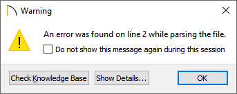
Did you maybe get this error before and then select "do not show"? You can always reset your message boxes in your preferences.
Regardless, if you look at the file in another program, it should be pretty obvious that the file contains extra data that is not supported:

Thanks Dermot. Can I manually edit those first two lines to fix it? Just used this converter from a gpx I got from Google Earth data (which also didn't work) and this is the file it spit out.
https://www.gpsvisualizer.com/convert_input?convert_delimiter=comma&units=us&form:add_elevation=auto
-
Can anyone manage to convert the attached text file to a terrain? Using the Import Terrain Assistant, I click on this file and hit Next, and nothing happens. Thanks in advance.

-
I have to chuckle at the memory from years ago of people here scoffing at my suggestion that we would eventually have real time, photo realistic raytracing, that photo realism would just become the standard render mode. I guess it has been ten years , but here we are.....
-
On 10/22/2020 at 8:37 PM, Alaskan_Son said:

That did it, thanks again.
Bryce
-
With my note callouts set to 12 for the site plan, this is how it ends up looking, with the Note Schedule taking up way more space on the page than it should.

-
Thanks, but all that does is make all the text, in both columns, larger. I just want the text in the right hand column to get bigger to match the numbered symbol in the schedule in the left hand column.
Change your note text size in plan to 12 and see what it does to the schedule.
-
In the attached Note Schedule, I want my callouts fairly large since it's a fairly big site at a small scale, but in the Note Schedule I want my text in the schedule to match the note symbol. I have tried the various options in the dbx, but I can't seem to find a way to make it so the font sizes are more the same. What am I missing? Thanks in advance.

-
On 9/18/2020 at 9:31 AM, solver said:
Your wall may be reversed and you are seeing the interior side of the vent.
That doesn't seem to be it. It's the attic, so it has no room definition.


-
All these years, and my structural engineer pointed this out. Nice way to make sure rain gets into the attic. No easy way to flip it over I can find since it's a window and not an object. I assume I'm not the first one to notice this?

-
Turns out my issue was having Steam, but not the Steam VR app as well. Working now.
-
Seems I am having similar problems. I get "No Virtual Reality Headset Connected", but I do have it connected and it is working with the free Oculus tutorial stuff. I have also tried starting the Oculus and Steam softwares in various combinations.
Chief V12. GeoForce RTX 2060 SUPER/PCIe/SSE2

-
Saw that, will do. Thanks.
-
Have the Oculus and Steam softwares installed and running, but still says I don't have a headset connected, which I clearly do.
Chief V12. GeoForce RTX 2060 SUPER/PCIe/SSE2. The free tutorial stuff from Oculus works fine, so I know the headset is connected and working.
I have tried having the Oculus software and/or the Steam software open in various combinations and still nothing.
Any ideas?


Material won't cover entire wall without having multiple duplicates
in General Q & A
Posted
There's a fairly quick and easy way to create seamless textures in Photoshop, or similar softwares. It seems complicated at first, but not too bad when you get the hang of it.